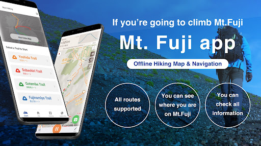
Features Mt. Fuji - GPS Trail Map
Mt.
Fuji App is a hiking trail map application that can be used as a GPS for climbing, hiking, trekking, trail running, and other outdoor activities.It utilizes data such as maps, routes, and place names that can be used for climbing Mt.
Fuji, and allows you to check your current location with GPS even in the mountains where the Internet connection is not available.Features(1) Offline trail mapMt.
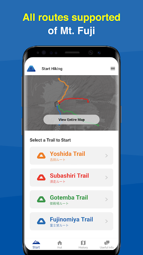
Fuji trail maps can be used offline.Even in the mountains where there is no internet connection, you can use the signal from GPS satellites to locate your current location and display the map.(2) Easy preparationYou can start hiking by simply selecting your trail route from the four routes commonly used for climbing Mt.
Fuji.(3) Mountain hut/lodge informationYou can also make reservations by phone or through the website for huts located along your planned route.(4) Leave history of your hikeWhen you start climbing a mountain, you can store a GPS log of your hike using GPS.Even if you are on airplane mode or out of range, if the sky is open, you can store a GPS log using satellite signals.After you finished your hike, you can get your own Climbing Certificate of Mt.
Fuji.(5) Voice notification of wrong wayWhen you deviate from the planned route, you will be notified by voice.You can also use the speech function that periodically notifies you of the current time and elevation after you start climbing.(6) Easy to keep a record of your hikeYou can easily create a record of your hike using the GPS logs and photos you took while climbing!You can also export the GPS log or post it directly to Yamareco (in Japanese only).(7) Latest Mt.
Fuji conditionsBy signing in YamaReco, you can check other peoples Mt.
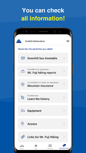
Fuji records and check the current mountain conditions.Knowing the current mountain conditions can help you prepare appropriately.(8) Useful InformationThe app includes information such as downhill bus timetable, mountain insurance, equipment, access, and related links useful for climbing Mt.
Fuji.NotesWhen keeping a GPS log, the GPS function is used continuously in the background, which may drain the battery faster than apps that do not use GPS.Continued use of GPS running in the background can dramatically decrease battery life.Please be sure to bring a paper map, compass, spare batteries, and power cable with you when climbing mountains.To use some of the functions of this application, you will need to register as a user with YamaReco.How to use the applicationhttps://sites.google.com/view/fuji-ios-en/
Social Features
Connect and share with friends and the community.
Gaming Features
Enjoy immersive gaming experience with various game modes.
Camera Features
Advanced camera features with editing capabilities.
See the Mt. Fuji - GPS Trail Map in Action
Get the App Today
Available for Android 8.0 and above